Between Thursday 6th October and Monday 10th October, our Year 10 and 11 Geographers went on an action-packed tour of Iceland, visiting various sites of geographical interest and learning about the country’s unique landscape. Read on below to find out what they got up to…
Day 1-2 – Thursday 6th – Friday 7th October
After a long day at school, we made our way to Heathrow Airport. We eagerly arrived and said hi to Miss Mackenzie and bye to our parents. After exploring Terminal 2, we got to the gate where we saw our fellow Iceland pilgrims’ faces turn less avid. Nevertheless, we scrambled onto our flight, dazzled by the foot room and onboard entertainment. After our three-hour flight, we tiredly got off the plane, met with our tour guide, Nick, then left the airport. The air was unexpectedly freezing, but to look on the bright side, our skin felt rejuvenated by the time we got to the coach! Shortly into our journey, Iceland welcomed us with a spectacular display of the northern lights showering the skyline! The next day bright and early we woke up, got ready, packed our bags and went down to breakfast.
Our first stop of the trip was the Golden Circle tour (‘the honey pot’- or as Mr Allan likes to call it- ‘the money pot’) wherein we saw Þingvellir, a Rift Valley where the North American and Eurasian plates meet, the first seat where the Icelandic Parliament met in 930AD. We also saw Drekkingarhylur, a lake where witches were drowned! We then visited Geysir, a geyser that erupts unpredictably and saw Strokkur erupting (it erupts every 4-6 minutes), one of the group said they were ‘shocked, but not surprised’ when she first saw the eruption. It was followed by an eggy smell which we found out was common with water in Iceland due to high Sulphur content. We then took a wander around Gullfoss, a large waterfall consisting of two waterfalls, 14m and 18m high. That was very exciting and we were all stunned by its sheer size, taking the time to close our eyes and feel the waterfall spray. Overall, day 1 was a sensational introduction to our Iceland experience.
Nelya K, Year 11 Geographer
Day 3 – Saturday 8th October
We woke up today in Hveragerði in the South of Iceland with wet conditions and high expectations. After making our lunches and having breakfast we set off to Seljalandsfoss, a 65 metre waterfall, which is the fourth tallest in Iceland. The Seljalandsá River falls over the old cliffs of the south coast, forming the waterfall. We went up in our full waterproofs and endured the spray whilst walking behind it, seeing it from all angles. It gave an incredible view of Seljalandsfoss and it was an incredible experience for us.
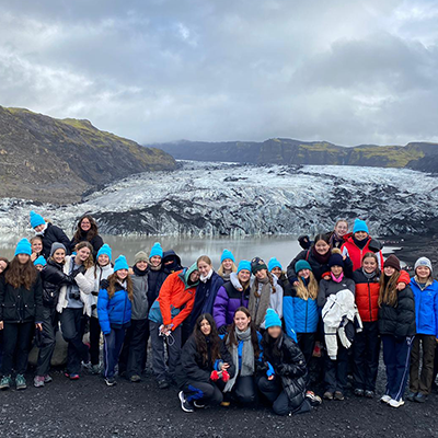
As the conditions started to brighten, we went up to visit the glacier Sólheimajökull. This outlet glacier is a part of the ice cap of Myrdalsjökull on the south coast of Iceland. It’s one of the closest glaciers to Reykjavík. We were able to see firsthand the effects of climate change with the distance the glacier has retracted in 10 years. As we were leaving, we also saw examples of chemical and physical weathering of rocks explained to us by Mr Allan and our tour guide, Nick.
After a quick lunch, we then visited Dyrhólaey and Reynisfjara, raised beaches giving us incredible views of the North Atlantic Ocean. The sands and rock on these beaches are both black as they were composed of basalt and gave us the opportunity to look at the erosion provided by the destructive waves to the coastline.
Finally, after a stop off for snacks, it was a trip Skógar, Iceland’s smallest village with a population of 25, to see Skógafoss, a 62 metre waterfall. After a quick look, it was back in the bus for the journey back to Hveragerði for the night.
Katie G, Year 10 Geographer
Day 4 – Sunday 9th October
We started the day off with a hot springs hike in Hveragerði. After a few minutes of walking with the snow falling around us, we started to smell the unpleasant sent of sulphur, which told us that we had made it to the hot spring. As we examined the hot spring, we noticed that it had bits of white, red, and yellow in it which we were soon told were silica, iron, and sulphur. The descent down the mountain was swift as the cold urged us to move our legs quickly to minimise our time in the icy conditions and maximise our time in the warm shelter of the bus.
The next stop was a shopping mall. However, it was no ordinary shopping mall; it was once hit by an earthquake which produced a deep crack in the ground beneath it! We found we were able to jump from one side to the other side; one was labelled ‘Eurasian Plate’ and the other ‘North American Plate’. After drinking warm tea and trying Icelandic treats in the café, we hopped back on the bus to Raufarhólshellir to visit a lava tunnel which was formed during the Leitahraun eruption. Our guide talked about the different elements of the cave, for example how the sparkly substances on the rock’s surfaces were surprisingly (to me at least) bacteria. She also informed us that they hold parties in the caves because they’re free of echoes, due to the gas pockets in the basalt rocks. This is also why there were no bats in the cave as they rely on the sounds they create to detect obstacles in their path.
Our next stop was Reykavík, Iceland’s capital. Here we attended an experience called FlyOver Iceland where we got to view some of Iceland’s most iconic sites. We buckled into our seats and soon noticed that our legs were dangling over a spherical screen with effects such as wind and mist blowing into our faces. All of this made the experience unforgettable. Before we left Reykavík, we made sure to visit the Hallgrímskirkja Church. I think it was safe to say that this piece of architecture was one of the most magnificent sites we have all ever seen. Its simplicity and white toned pallet was very unusual for a church, yet it brought our attention to the religion and the towering organ at the back of the church.
To end our day, we fought the raging winds to reach a restaurant in Reykavík where we were all able to relax and look back at the day and the fun we had with our friends.
Mika B, Year 10 Geographer
Day 5 – Monday 10th October
On the final day, we visited the most westerly point on the Reykavík peninsular, where with a little imagination we could imagine the Mid Atlantic Ridge breaking sea level and stretching North-East across Iceland. During our travels of this peninsular, history unfolded before our eyes; we saw relics of the cold war and data centres for the cloud. The cherry on top of the cake was a luxuriating sixty minutes in the hot spring waters of the Blue Lagoon. With a fresh spring to our steps we headed to the airport for our return flight home whilst purring about the past four days.
Many thanks go to our tour guide, Nick and our coach driver for expertly and safely navigating our way around Iceland.
The Geography Department